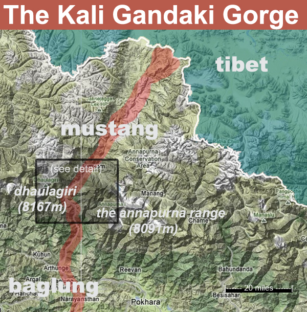
The Kali Gandaki Gorge, Mustang, Nepal
I recently had the good fortune of visiting the Mustang District, about 40km up-river from my home in Baglung Bazar. Mustang is divided into upper and lower regions; the lower is mostly within the Annapurna Conservation Area, which yes, does include the upper half of the famous Annapurna Circuit hiking trek and contains several very high peaks of the Himalayan Range (and thus breath-taking vistas). Upper Mustang lies just north of the Himalayan range and borders Tibet, and the landscape and culture in fact greatly resemble that of the Tibetan Plateau. Upper Mustang is the more famous of the two and requires a special access permit for entry – $500 USD for a 10-day access pass – which was introduced to protect the area from it’s own popularity (many Tibetan culture enthusiasts view the region as an accessible alternative to travelling to Tibet itself). Because of this, and time limitations, I only visited lower-mustang during this go-round.
Essentially, my trek followed the Kali Gandaki Gorge North, starting from my house. The Kali Gandaki river begins at 20,546ft in elevation near the border with Tibet and flows south through Mustang District, passed my house and down into India where it eventually feeds the Ganges River. Along the way, the river passes through an incredible diversity of climactic zones, serving as miniaturized example of Nepal’s diverse geography.
The journey began outside Baglung Bazar, the small urban settlement in sub-tropical conditions at 3500ft where I live. Where the hillsides aren’t carved into terraced grain fields, the forests blend between pine and jungle flora. Banana, orange, and pine trees thrive and tribes of monkeys migrate here during the hot, wet monsoon. Cows, chickens, goats, street dogs, hawks and eagles dominate the animal presence, but warnings of “jungle-cats” proliferate (the name Baglung is in fact derived from the Nepali word for tiger). At night, the hillside glitters with lights from houses – evidence of the dense human presence here. We spent an afternoon hiking down into the river gorge then upriver through a couple modern bus-stop towns of concrete pillar buildings into the next major municipality of the region, Beni Bazar. The path followed a paved highway equally utilized by over-filled buses, taxi-jeeps, tractor-freight, motorcycles and pedestrians, the majority of which reached their arrival at the bazar.
The following morning we caught a micro-bus for the first official leg of our journey: Beni to Ghasa. For this leg, we opted to use motorized transport so that we could spend our limited time trekking at higher altitudes. The pavement ends in Beni, leaving a semi-maintained 1 & 1/2 lane gravel road into Mustang. Apparently the road was only completed 5 years ago, and was not well received by the international trekking community (although I suspect it was welcome by the locals). The gorge was impressively steep and narrow in this stretch, with evidence of numerous seasonal landslides where the rocky slopes made their annual contribution to the river bed. The sub-tropical feel of the forest gradually dissipated. We officially crossed into the Annapurna Conservation Area in a town called Tatopani, which means “hot water” (one of many, many towns in Nepal identically named for its hot springs), and about two hours later we disembarked the microbus to began our journey on foot in the small town of Ghasa, at roughly 6000 ft in elevation.

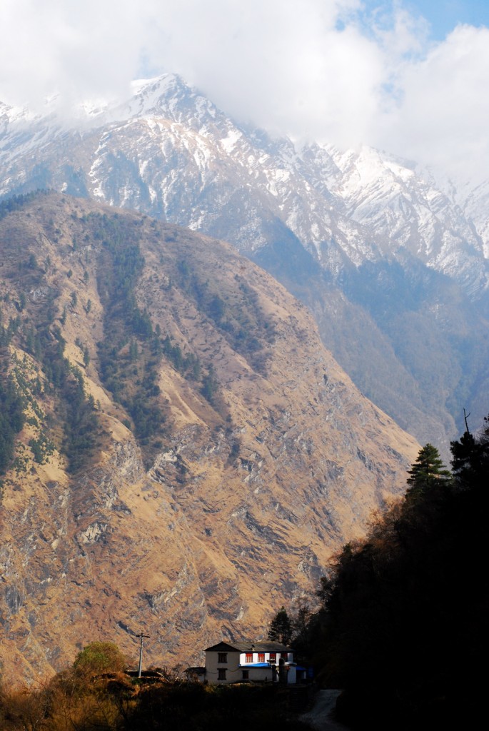
Ghasa has a distinctly alpine feel, situated on a narrow flat in the hillside with a tall alpine ridge to the west and a steep drop to the river on the east. The footpath through town is paved with the same stone with which the houses are built. A handful of colorful flags stood tall above the roof line, proudly marking buddhist households. From Ghasa, the trail followed the road as it climbed up the canyon before dodging into the forest for a mile or so. At this point, things started to feel like home – the look of the forest, the smell of the pines. But with one notable difference: the outer 3-4 inches of numerous pine trees had been hacked away from their base up to about 7 feet – clearly the area within reach of a person. A potentially sustainable way of harvesting fuel wood, we wondered? The trail popped back onto the road again to cross the river and climb into a broad basin where the small town of Lete sits. The canyons sudden breadth left inspired awe after miles of narrowness. The landscape had clearly fully turned alpine and suggested many harsh arid months. The bushes were short, straggly and usually quite thorny. Pine forests thrived in clumps. Our guidebook mentioned Himalayan Bear spottings in the region during the fall (a worthy reason in and of itself for a return trip). We pushed through Lete hoping to make it to Larjung for the evening. Instead we stayed in the smaller town of Kokhethati where we stopped at a guest house for dinner. Kokhethati occupied the east bank where the gravelly river bed stretched about a kilometer wide. Clearly the river consistently changes course during the rain season, probably flooding the entire plain during its peak. Kokhethati, nearly level with the river bed, sits at 8500ft above sea level.

After awaking to a lovely panoramic view, we decided to take a side trip up the western canyon wall to a viewing point for the Dhaulagiri Icefall. This was a lovely decision. We quickly hiked up to Sekong Lake on a small plateau and dropped the majority of our things as we intended to camp their that night. As we were sorting on the lake shore, we heard a slow crescendo of cow bells – and out popped a herd of YAKS, eager to quench their thirst and cool off in the water. I personally admire Yaks as the bad-ass of the bovine family; they can handle ridiculously steep terrain, carve trails in thigh-deep snow, have ridiculous and useful wooly coats and tails, and are an equally-useful sources of dairy products as their cow cousins. As I said: bad-ass. After snapping the requisite dozen photos, we continued on a steep path up the slope, crossing through pine forest passed the tree line and through another yak field, this time complete with a small yak-herders shack. Up and up and up we climbed along a shaggy slope of grass clumps with an increasingly gorgeous view of Mt Niligiri to the east. At around 12000ft, we reached snow on the trail, at which point I had to call it quits. Having inflamed my ever-weaker right ankle the day before, I didn’t want to risk a bad injury sliding down a steep snowy trail. There wasn’t much to complain about though – I could hardly imagine a better setting in which to take a break.
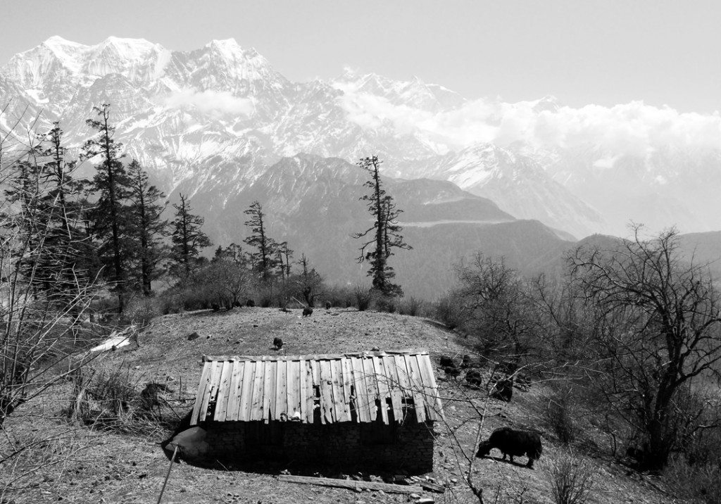
As we hiked back down the usual late-afternoon clouds rolled in and threatened our evening with rain. After stubbornly making a campfire with damp wood to make s’mores (our country director had sent us marshmallows!), we admitted defeat and retreated from the rain by setting up camp inside another seasonal yak-shack not far from the lake.

The next day, the third day, we continued the hike up the Kali Gandaki gorge, which remained impressively wide and flat. Along the way, we took tea breaks in the towns of Larjung and Tukuche. Again, the footpaths through town were paved with stone, lined with stone walls and stone houses, which in turn were lined with stacks of wood. Along the river were numerous small apple and apricot orchards. Near the beginning and end of town stood rows of Buddhist prayer wheels. The natural landscape and built environment there were so so different from my post; admittedly, this was the Nepal I’d imagined I’d be stationed in for service . . . For centuries, the town of Tukuche was a regional trading post – the city where Himalayan salts from the northern Tibetan plateau were traded for grains from the southern plains and terraced hills (it’s neither hot nor wet enough for rice to grow in the upper Himalayas.) Wool, livestock, and dairy products were also traded for sugar, spices and manufactured goods, but the salt-for-grain trade dominated the exchange. There are only 12 major passable trails between Tibet and Nepal and four of the easiest are in Mustang, including the Kali Gandaki Gorge. Thus the region grew quite prosperous from the exchange. But political and economic changes all but halted the trade route around forty years ago, between the political situation in Tibet and India making cheaper, iodized sea salt available. The region fell into economic decline and currently sustains itself through its orchards and the trekking industry.

Mid-afternoon once again brought clouds, this time with thunder and more rain. We layered on our gear and continued up the gorge through strong winds until the the path took us to a somewhat sheltered ridge along the now south bank. The landscape now resembled the high-altitude deserts of the American south west. Along the route we passed through the ruins of an old concrete Tibetan refugee camp, and then a quaint contemporary Tibetan community. The weather kept the streets vacant of people, so we pushed on to our destination, eager for warmth and nourishment. Once we’d dropped our things at a cozy guesthouse in Marpha (9100ft), we explored the narrow streets in the waning daylight. The small town is tucked beneath a steep, barren hillside, with winding stone pathways and uniformly white-washed stone walls. An impressive water system flowed beneath the footpaths, with removable stones for easy access. Our hostess informed us that the Buddhist Gompa was still open up the street, and were indeed welcome upon finding it. The interior was brightly painted with murals containing thousands of different deities on the side walls. The far wall proudly displayed three large cross-legged statues, equally bright. One of the most interesting features to me was the grid of shelving which contained around a hundred ornate, long, rectangular boxes that held the reading cards for prayer. Back at the guest house, we kept our feet warm by the small stove beneath our table before enjoying pasta and fresh apple pie. After a cold night in the open and a cold day in the wind and rain, I thoroughly enjoyed a cozy night’s rest.

We all bought several bags of dried apples, apricot preserves and Sebuck thorn juice concentrate on our way out the next morning. Upon returning home late that night, a couple long and bumpy jeep rides later, the treats reminded us of that serene alpine land to the north, a corner of Nepal we’d caught a quick glimpse of . . .

Speechless…
I very very like Kali Gandaki